Our journey begins with a scenic one hour flight from Kathmandu to Nepalgunj, a border between Nepal and India in the southern part of Nepal. It is a busy crowded city and a business hub which lies close to the Indian border. Nepalgunj is the blend of Indian culture and Nepali traditional cultures. Indian border is just five miles (8km) away from the city. And it comes as no surprise that it looks more like an Indian city than it is a Nepali one. The temperature is high here and the condition humid for most part of the year. You can also drive from Kathmandu to Nepalgunj by bus which takes about sixteen hours. You cannot fly directly to Humla. You have to stay in Nepalgunj overnight before you catch a plane to Humla. You could do shopping in around the city where you can find goods in a cheaper price. You will check in to the hotel for a night.


On the following day, we fly from Nepalgunj to Simikot. We have to fly north for about 45 minutes to Simikot, the headquarters of Nepal’s most remote district, Humla. The trip is a thrill ride through the ridges and ravines in the spectacular mountains. The landing at the tiny mountain airstrip at Simikot is an unforgettable experience. It is no less adventure as it is just a graveled airstrip (scheduled to become asphalt soon). You feel like you are in a different realm because of the sudden rise in altitude and sudden fall in temperature. To leave behind the scorching hot climate behind, to be in a tiny mountain village and to be breathing cool and fresh air gives you adrenaline rush and refreshing feel. Simikot is situated on an airy spur above the Humla Karnali River and you should take time to explore the town and some of the surrounding villages to discover a way of life that has barely changed in hundreds of years. You are going to spend your night in Simikot.
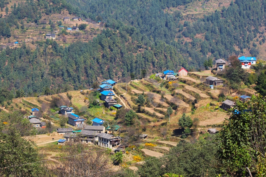
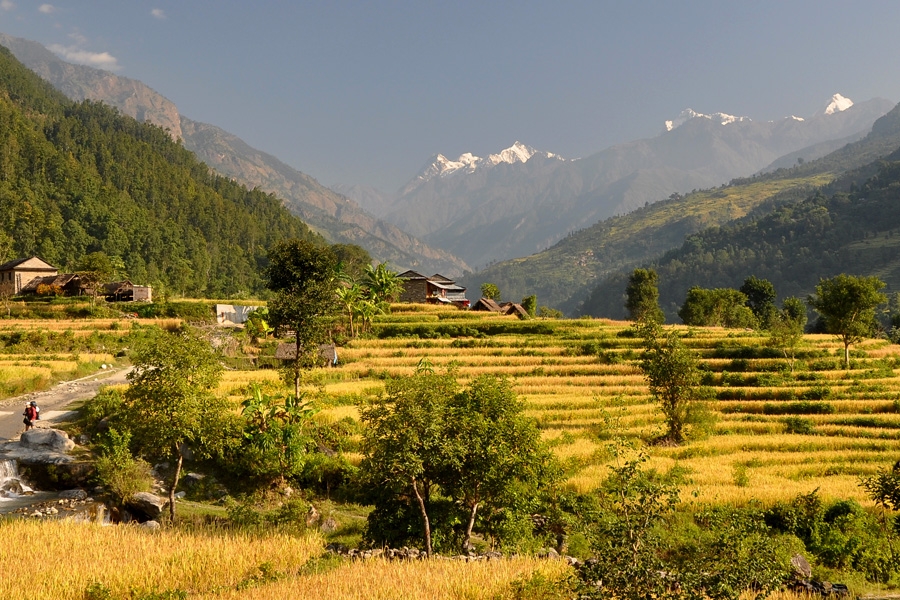
We commence our trek, climbing up from the airstrip on a rocky trail passing fields of barley and wheat. We then ascend a forested ridge above the town of Simikot. From there it is a descent of about an hour to Majgaon. We have to trek through the pine forest where we can see local Hindu and Buddhist people in their traditional attire accompanied by their herds of cattle. The cattle carry the load for the people in this part of the world because there are no other modes of transport. If the cattle are not available then the people carry their loads on their backs and take them all the way up. Once we pass Majgaon, the track gets uneven. On the one corner it is descent whereas it is ascent the next corner. This particular topography is called Nepali flat. It is green and lush than what you will see a little higher. We will spend our overnight in Dharapuri.
On this day, we will have a pleasant walk enjoying the surrounding environment. The track keeps altering the elevation within matters of a few hundred meters thus making the trek unusual. The trail stretches alongside the Karnali River and we will walk right along the bank of the river. There are going to be times when you will be looking down on the river working its way through narrow gorges and high rocky slopes. You will get chance to closely observe the pattern of cultivation there, as your trek continues along the farming area of the locals. Most of them grow barley, buckwheat, potatoes and rice. If you reach at the village early, then you can take out some time for hot spring bath. It just takes 30 minutes walk to reach the spring from Kermi Village. Kermi Village is the first Buddhist villages you are going to pass through during your trek. It has two monasteries; Lakiyo Gompa and Lhundrup Choeling Gompa. The former is a few centuries old. The latter one is relatively new and was built less than a hundred years ago. The monasteries are not often visited by the tourists. While you stay overnight here, the howls of jackals and hyenas keep reminding you that you are at the lap of the nature.
Leaving Kermi, we will have to ascend through a steep trail for about two hours until we reach small pass. The trail goes alongside the fields with different species of lizards and other creatures traversing your path. You cross the pass on a big iron suspension bridge dangling over the Sali River. It is all descent from this point forward. The trek gets better from here as there are beautiful pine trees above your head and emerald Karnali down the hill. Do not be surprised if you bump into caravans of mules and dzopas (crossbreeds of yaks and cows). They are the local villagers Simikot and Nyinba Valley travelling to and from Taklakot, a trade hub across the Tibetan border.
Yalbang has so many places and heritages to offer that you could easily spend an extra day here. Namkha Khyung Dzong Monastery is one of them. Right in front of the yard of the monastery you will be welcomed by a mammoth rock with Tibetan mantra written all over it. The monastery also happens to be the largest monastery in the region which is sheltering about 130 monks. The monastery originally comes from the Nyingmapa Lineage, the oldest Buddhist lineage. Legend has it Nyingmapa Lineage was founded by a great magician Guru Rimpoche around the 7th century. The monastery has a huge statue of Shakyamuni Buddha and other smaller statues along with that of Guru Rimpoche. The monastery also runs a school and a clinic. If you ask a monk he will be more than happy to show you around. Every morning at 7 and afternoon at 4, the monastery has customary prayer sessions. You can get soaked with the spiritual vibes by being a part of the ceremony. Please be quiet and remain behind the monks near one of the walls they had there. Spend your night in the here with the howls of jackals and hyenas coming from the distant bushes.
Leaving Yalbang, we continue our trek to Tumkot. Our primary flat trail will lead us to a small village called Yangar. Then we begin our walk on three sided tunnel like trails that are carved out of gigantic boulders. As you walk further, you will experience the climatic change along with the vegetation too. The greenery begins to vanish and so do the smaller bushes. They give way to the pine trees and rocky hillocks in large part. We then cross a huge wooden suspension bridge over Karnali River. Afterwards, we start climbing the rocky mountain until we reach the apex of the deep gorge. En route you will witness the ancient modes of trade still existing in same old fashion like the sheep carrying the sacks of salt on their backs. You may come across the big army tents set up in a few places. They are the mobile restaurants and cafeterias serving tea, coffee and quick snacks. You will pass by the village of Muchu before reaching Tumkot. Tumkot lies in the sideline of the main trail which dissects a small market right into two. The village is the proud owner of Dhungkar Choezom Monastery, which is affiliated to Shakya Lineage. It is considered one of the important monasteries in the Tibetan region. The monastery sits itself on top of a rocky mountain which takes about 20-30 minute walk from the foot of the mountain. Dhungkar Choezom Monastery is the only Shakya monastery in Humla as there are only a few of such monasteries throughout the country. If the curator of the monastery is available then he will give you insight on every minute detail that the monastery has in its bosom.
After breakfast, we start our trek ascending uphill through steep trail. You will soon start to feel the climatic change along with the change in vegetation and landscape. After a few miles of hike the change begins to mark its authority. The landscape becomes more rocky and desolate. The trees that you see are not pine trees anymore. Now we can see short and low junipers. On the other end of the road is a village Pani Palwang with some tea houses which is a perfect place for a short time out and a cup of tea or lunch. From this spot, it takes just an hour and half to reach Yari village with cultivation, where there is check post between Borders. While you stay at Yari village, enjoy the views of Erega Mountain and vicinity of Thado Dhunga (4,043m).
This days trek is going to be quite tiring and tough. Now the landscape starts to look more like that of Tibet. Every few hundred meters you bump into the herd of dzopas, mules and even yaks. The bigger yaks specifically might catch your attention. The ascent gets vigorous after Thado Dhunga. On the way, you can also see the Tibetan Plateau. The last thing you want to see on your way is the residue of snow because that is only going to add few more agonizing hours to your trek. Even after the Nara La is in your sight the job will only be half done because it is not easy to seal the deal due to altitude factor. You can see the piles of stones, which are meant to bring good luck on you, prayer flags and prayer chants looming in the air with the strong breeze. What’s more! You are instantly captivated by the breathtaking view of Tibet on the one side and spectacular view of Yari Village down below. You will find barren mountains in brown, copper, ash and dark yellow colors as far as you can see. On the way, you may encounter Blue Sheep above path with rolling stones going down all the way to river. From here on, it is a shaky descent down until you find yourself standing in the border of Nepal and Tibet. Hilsa is a border town on the Nepal side of the Nepal-Tibet border. It is also a dropping point for the pilgrims on the way to Mt. Kailash.
The trail continues after crossing a huge iron bridge at Hilsa. Then we move along a narrow trail that winds its way up until we connect with the main route on the higher slope. The trail stretches alongside the Karnali River all the way to Manepeme. The path continues to put your physical strength to test with ups and downs which is quite adventurous though. The landscapes, barren mountains and their iridescence blow your mind away and you have a little or no time to feel tired. From the path, the Humla Karnali looks very deep down. Finally we reach Manepeme where we will stay overnight.
On this day, we have to ascend for about couple of hours. Then you can choose between a small path that stays at the same level for a while and the wider path that starts going up immediately. The benefit of sticking to the narrower trail is that it takes you to a meditation cave, Ya Yip Phuk. This cave holds an old but important tale about the history of Buddhism. Lotsawa Rinchen Sangpo (985-1055 AD), a famous translator of Buddhist scriptures, meditated in this very cave. He also led the movement that revived the cultural exchange between India and Tibet. It ultimately led to the promulgation of Buddhism in Tibet. Also, the trail is teeming with lush and green vegetation. You can find rampant juniper trees along with some other shorter bushes. Continuing our trek, we need to keep going up until we arrive at Lamka La (4300m). The trail gets smoother from here, as the descent commences all the way to Til. Til is a beautiful Tibetan village like any other village in Limi Valley. The gateway to the village is a chorten. The villagers still wear their traditional dresses. Men wear a long thick brown coat, with one sleeve down and the women wear a long brown or blue dress with a colorful apron made from yak wool. They keep their heads covered with a long colorful cape. They have beautiful jewelry with big turquoise stones. The senior citizens spend most part of their day in spiritual activities, spinning around prayer wheels and humming “Om Mani Padme Hum” meaning roughly “blessed is the jewel in the lotus”. This mantra (chant) is believed to be possessed by Avalokiteśvara, the bodhisattva (a Buddhist half god) who supposedly stays on Earth to anchor humanity to enlightenment and compassion. When you call it a day, you head to a tent and get a sound sleep. As you get closer, you will find first sign of the village is the white buildings attached to the slopes which is a monastery with some retreat houses in its perimeter. The houses are perfectly colored to camouflage in the surroundings. By the time you have arrived at Til, you will find the environment has gotten green veils for it. The soil is fertile and you can tell that from the view of birches and terraced barley fields. Two beautiful snow mountains have your back at all times.
Early morning, you can walk around the village and have a look around the monasteries. The Limi River fills Karnali shoes as Limi River accompanies your trail. The walk is relatively easy and smooth. Keep an eye on the vicinity around you because you never know when those highly endangered species are going to show up. You do not want to miss out on such an opportunity. With luck on your side, you might come across mountain goats, snow leopards, and even blue sheep. The village is camouflaged into the environment so much so that you find it hard to locate at once. Once you go through the chorten you will see a big Mani wall. Mani walls are low walls built up with many stones with holy mantras and Buddhist deities carved on them. The village is the shelter to a 14th century monastery Richening Gompa. The monastery is affiliated to Kargyupa Lineage. Richening Gompa is the holiest Gompa in the region and is also the centre of religious activities in the Limi Valley. This monastery is known to be one of the oldest monasteries in the Nepal Himalayas built in 11th century. The monastery is very well taken care of with the help of Nepal Trust. Dalai Lama also visited this monastery several times. It offers a great many things to visit inside. The main hall has a well decorated idol of Shakyamuni Buddha. Other rooms have smaller statues, a completed version of Kenjur (the Buddhist scripture), masks and costumes used during different cultural carnivals. They do not charge you for the entrance but you have to pay and additional cost for clicking the picture. Your stay overnight will be at one of the teahouses. People of this area sell maple woods tea pot, soup bowl, pots and more handmade things.
Today’s trek is quite short and relatively easy. We will be accompanied by the Limi River along our trail. It is relatively a relaxed trek of four hours. Jang is the third and the last village of Limi Valley. And like all other village it is nothing short of majesty, surprises and beauty. As far as Jang is from the modern hustle and bustle and as free as it is from the modernism, Tibetan cultures come alive here at their purest. Jang, too, has a beautiful Gompa which you can visit. The charge is free but like in Halji they will charge you a nominal fee of for clicking some pictures. Today’s night will be spent in at one of the teahouses.
Though today we have to walk for a long hours but it is worth it. We will be walking through a beautiful trail which will entertain you with panoramic views Api Saipal Himal (7025m) and Mt. Kailash. The best part about today’s trek is that until Kermi there is no human settlements. It is going to be you and the most surreal landscapes full of adventures. With that said, the trail gets tougher at times and you are going to have to cross quite a few rivers and streams. The trail remains slow and steady and goes up until Talung. Talung provides you a fair bit of leveled ground to camp at. You will be staying here in a tent overnight at grassy meadow.
On this day, you will be trekking to the highest point of the trek among the whole trekking days. Nyalu La pass lies at the altitude of 16,207 feet above sea level. Your work way up the pass is surely going to be a daunting task. However, it is once in a life time opportunity to get to as high as 5000 meter and you want to take your trekking experience to the whole new level. Snow on the trail, 360 degree view of Humla and Tibet, the glimpse of glorious mountains like Mount Saipal (7031m), and Mount Kailash (6714m) make you want to push the limits. The path climbs down after you are beyond and across the pass. The altitude plummets to 4630 meters by the time you are in Lake Selma Tso. The downward slope continues on its course all the way down to Shinjungma which is also the campsite for this day. The changing vegetation and climate, the Sali River, steep slopes, Mount Kailash and the overnight stay in the tent are the salient features of this particular day.
Retracing your footsteps, you will trek back to Kermi. The walk does not get any better because you will be treading on the solid grounds amidst pine and birch trees and Sali River by your side. The trail takes you to the Karnali River and your parade heads eastbound. You can relax a little bit here and dip your tired body into the hot springs before seeing off your day in a tented camp.
The day begins with few ups and downs along the road. The walk up to Dharapuri (2300m) and Majgaon(2290m) is nice and smooth. It is after Majgaon that the trail decides to turn hostile. It is a two hours walk up the hill from the Karnali River until you reach a pass at the height of 3000m. From there on, it is half an hour walk to Simikot. You get to drink refreshing soda or drinks in Simikot and even hot water shower. The night number 18 will be spent in a tent.
On the last day of our journey, we take and early flight from Simikot to Nepalgunj and then connect flight to Kathmandu. After arriving at Kathmandu with some life long memories of the tour, you will be escorted to your respective hotels. You will have spare time to scan through the market in Thamel. After about two weeks and half you will be spending your night in a cozy hotel suite.


Discover incredible offers for your upcoming adventure by subscribing to our newsletter with the latest travel tips and updates.