Nature Trail

Guerilla Trek - 14 days

Save
US$ 350
Group discount
US $2,560
US $ 2,210
  • Best price guaranteed
  • No booking fees
  • Earn US$ 0 in travel credits.
Max. Elevation
3195m
Group size
2 min - 16 max
Trip grade
Beginner
Transportation
All the Grounded vehicals are inclusive in packeges.
Best Season
Aug - Nov , Feb - May
Accomodation
Lodge + Camping twin sharing bed basis during the trek
Meals
All Meals ( Lunch , Dinner and Breakfast) with Cup of Tea/Coffee during the Trek.
Starts at
Kathmandu/Pokhara
Ends at
Kathmandu/Pokhara

Highlights

    • Scenic drive through countryside with rural setting
    • Natural landscapes, terraces of Jaljala region.
    • Culturally rich – Kham Magars  in this region.
    • This place has brought political history.
    • Trans - Himalayan views of the mountains.
    • Explore Mid western nepalise Culture.
    • Camping trek in Nepal.
Guerrilla trek is newly open non tourist trekking trail, located in far western part of Nepal. This trek provides you an opportunity to see the effect of Maoist civil wars and its effect in Rukum, Rolpa and other many districts at far western part of Nepal. You can hear the stories from the local people of war which lasted for about 10 years which will provide you an insight of how miserable the life would have been of the people during those periods. This area is not only historically important, but also important for its natural beauty and Dhorpatan Hunting Reserve, which is the only hunting reserve of Nepal. The trails are for the unique traveler seeking an experience that could long ago be had in Nepal’s well-established areas.

Guerrilla trail offers a journey through heartland of post-conflict territory; natural resources, biodiversity and rich culture heritage of ethnic group of local people. Guerrilla trek Nepal will give tourists an insight into the insurgency, highlighted feature of gorilla trek Nepal is to introduce the visitors the real image “how the guerrillas operated and fought during the conflict”. Guerrilla trekking trail of Rukum-Rolpa area is a virgin land, restricted, impossible and extremely difficult for outside world over a decade during long people’s war in Nepal. The land is known as most playground for revolutionary people, their perfect hideout and running their own government. The small yet naturally beautiful place is now open and heartily welcoming people from outside. The place is blessed with rich flora and fauna, unmatchable natural beauty, rich cultural heritage and adventurous trails once used by Guerillas during people’s war in Nepal are the main attraction in Rukum. With their main occupations of agriculture and foreign employments, conflict has changed their social life and looking further to prosper economically through tourism. Chartering through the rugged terrains and crossing the routes of Myagdi, Rolpa and Rukum can indeed turn out to be a thrilling experience. The most remarkable feature of this region is the diverse biodiversity and the wide range of natural resources. The area is dotted with waterfalls, rivers, vast wildlife, huge lakes, caves and dense forest. The glimpses of the towering Himalayas, Dhaulagiri, and Annapurna massif make this trip even more enticing. Apart from the vast natural resources and bio-diversity, the rich cultural diversity adds to the highlights of the area. However, the infrastructural development in the region is inadequate. Rukum and Rolpa were the homeland of many revolutionaries. The districts were also the epicenter of the Maoist insurgency. It is also challenging to make the locals aware of how they could reap benefits from tourism. This region is blessed with wide ranging natural resources and biodiversity. Captivating waterfalls, rivers, caves and lakes like Kamala Daha (Lotus Lake), and Sun Daha and high Himalaya to the north are some of the main attractions. Kham culture is a unique feature of the northern Rolpa and eastern Rukum. The Khams are a sub-group of the Magar community distinguishing customs and unique language of the Tibeto-Burman family. Paddy is cultivated up to the mid-hills and barley, maize, millet, wheat, and potato as well as apples and apricots are farmed in the upper hills of the region. The area also boasts a lot of wonderful high elevation meadows used for monsoon pastureland of cattle and buffalo, and foraging for Yarshagumba, also known as the Himalayan Viagra in the rugged highland.

Even though Maoist civil wars cover most part of far western Nepal our trekking trail cover Rolpa and Rukum district it is because Rukum and Rolpa is the starting place of Maoist civil war. Guerrilla trekking route is designed with the combination of major destination of civil war in between Nepal Government and Maoist. Now, trekkers can retrace the footsteps of the guerillas and imagine what it must have been like to hike and fight in this kind of terrain. Gorilla trek starts from west of Pokhara city (Myagdi district) at part of Annapurna trekking region Nepal. Guerrilla trekking trail passes along the route where thousands of Maoist guerrillas once dug trenches and ambushed the army, throw rugged mountains, caves, rivers, paddy fields, Landscape and Ethnic Magar villages then finally Guerrilla trail Nepal ending in Rolpa district. On 2/10/2012 Maoist leader Puspa Kamal Dahal (Prachanda) has launched a map and a guidebook of entitled Guerrilla trek, which the co-produced with American Travel writer Mr. Alonzo Lyons. Towards the end of the trek you will be passing through vast pasture lands, and magnificent Dhorpatan regions with dense pine tree jungles. Dhorpatan is only a hunting reserve of the nation where hunting activities can be permitted under control of wildlife provision law. The spectacular views, heartland of post-conflict territory, and the wonderful pathways will surely make your journey a memorable one. Thus, if you are a travel enthusiast, trekking along the rugged terrains of Guerrilla can turn out to be a thrilling and impeccable experience.

Trip Itinerary

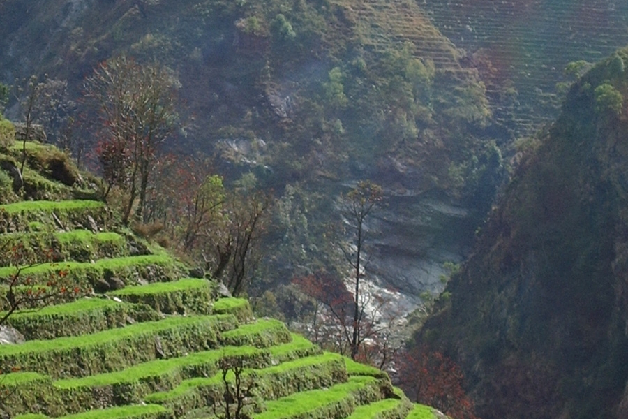
We start our journey with a scenic drive from Kathmandu to Pokhara. Along the Prithivi highway, you will be followed by Trishuli River on the right side offering you with its beautiful river view. After then, you will be accompanied by the Marshyangdi River as the trail up streams to its junction. You follow the Marshyangdi gently up through heavily terraced fields and small hill towns to the Seti River that takes you directly into Pokhara. Having pleasant weather, Pokhara is tourist’s paradise with full of natural as well as cultural heritage sites such as lakes, caves, temples of Buddhist and Hindus along with mountains. You can observe views to the north across the hills and Phewa Tal (lake) to the white peaks of the Annapurna and Dhaulagiri ranges. You can also take a flight from Kathmandu to Pokhara instead of drive which will just take 30 minutes to reach Pokhara from Kathmandu. After arrival, get refreshed and stay overnight in hotel.

elevation

Max. altitude

850m / 2,789 ft.
accomodation

Accommodation

Hotel
meal

Meals

Lunch , Dinner , Breakfast

Starting our journey from Pokhara, we drive towards Beni for about four hours. Throughout our drive, we will enjoy the beautiful scenario of mountains, forest and country side. Beni is a small town located at the confluence of the Kali Gandaki River and Myagdi River at an altitude of 830 meters. Two rivers meet at the junction so it is named as Beni. It is the district headquarters and has a police check post where your trekking permits will be examined. It is a bustling town lined with stores, restaurants, hotels and various government offices. Anyone can watch panoramic scene of Himalaya and landscape, can observe flora, fauna, and village life style also. Different kinds of tourism activities could occur in a place in a visit like recreational tourism, Eco-tourism, Village Tourism and Cultural Tourism etc. It is a significant pilgrimage itself along with several temples and monuments. It is the head quarter of Myagdi District. It is the main gateway to reach Mustang and Tibet. The sprawling town lies in Dhaulagiri Zone at the confluence of the mighty Kali Gandaki River and the Myagdi Khola. Beni is a hub for trans-Himalayan trade and for travelers heading northward along the western half of the Annapurna Circuit. We stay overnight at this beautiful town.

elevation

Max. altitude

830m / 2,723 ft.
accomodation

Accommodation

Hotel / Lodge
meal

Meals

Lunch , Dinner , Breakfast

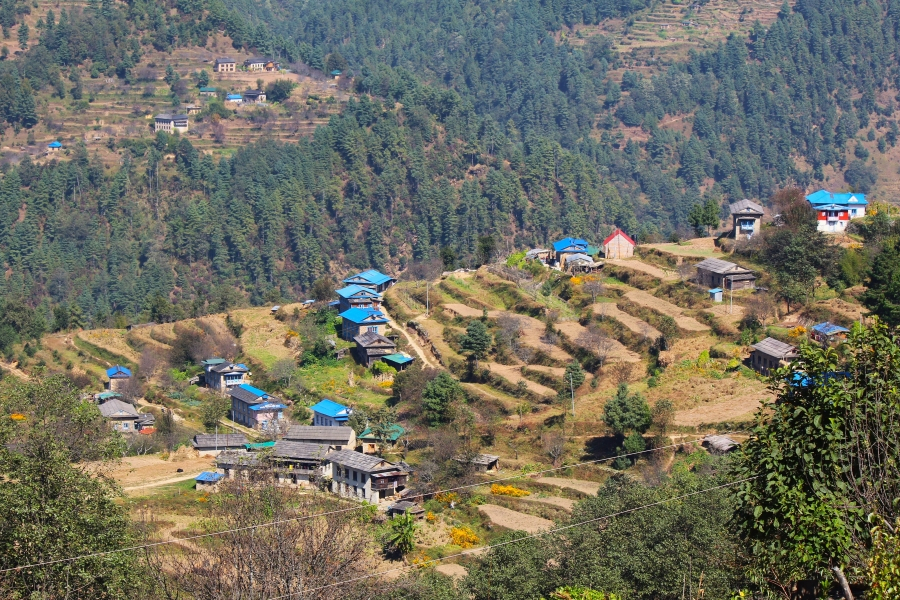
From the Myagdi district headquarter, one has to follow a gravel road for 24-km to Darbang and start walking. Takam is 37 kilometer far west from Beni Bazaar. It is one of the important historical places of the district. War weapon of medieval time and ancient war trench can still be found in that area. It is a beautiful village with attractive landscape as well as stunning views of Mt. Dhaulagiri and Mukut Himal. It is and ancient settlement of mixed community of all tribes: Brahmin, Chhetri, Damai, Kami, Sarki, Magar, Gurung, Thakali, Chantyal and many others. Main inhabitants are Brahmin and Chhetri. It lies on the way of Dhaulagiri Base Camp and Dhorpatan trek. Takam Kot is archaeologically and religiously important. We spend our overnight in one of the lodge of Takam.

elevation

Max. altitude

1,665m / 5,463 ft.
accomodation

Accommodation

Hotel / Lodge

Leaving Takam after breakfast, we move ahead towards Lamsung, today’s destination. From this point you can find the untracked part of Nepal. The wonderful view along the trail will make you always refreshed to walk further. You can find the remoteness here. This remote area with stream and gorges will be a wonderful place to explore. It is now a region of peace, ready and willing to receive tourists. Traveling in this area provides a chance to see rural Nepal and the cultures there unaffected by the commercialization of the travel industry. The beautiful landscape added beauty. Only few trekkers have walked throughout this trail, thus the local people are not used to foreigners. As this part of the area has also suffered a lot during the war, you can hear the stories of Maoist insurgency. You can feel the pain in their eyes while you hear the story. You can read their face, how they had faced 10 years (1996 – 2006) wars. You stay overnight at this village with local peoples.

elevation

Max. altitude

2,250m / 7,382 ft.
accomodation

Accommodation

Hotel / Lodge
meal

Meals

Lunch , Dinner , Breakfast

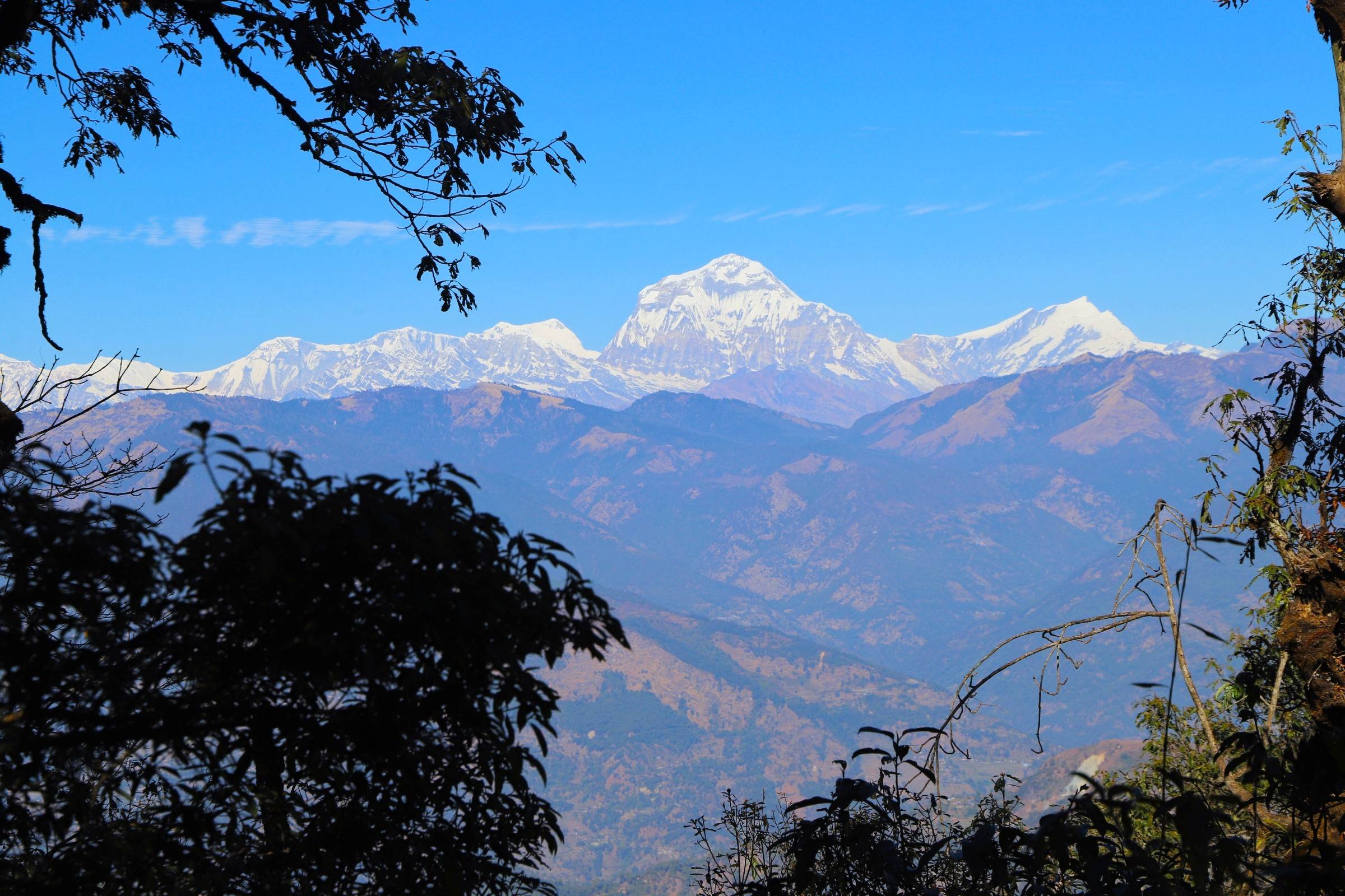
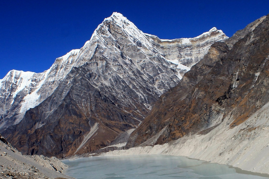
Leaving Lamsung, we trek through the dense forest of pines. You can also enjoy the musk deer barking behind the bushes. En route, you can also view the 180 degree views of Dhaulagiri which extends up to entire range up to Chure Himal in the west.  All along, there are spectacular views of the Dhaulagiri range from high ridges and large meadows fringed by pine forests. The trail has a historic attraction, but there are also challenges of infrastructure and making locals aware of how they can benefit from tourism. After a walk for about seven hours, you will reach Gurjaghat for your overnight stay.


elevation

Max. altitude

3,020m / 9,908 ft.
accomodation

Accommodation

Hotel / Lodge
meal

Meals

Lunch , Dinner , Breakfast

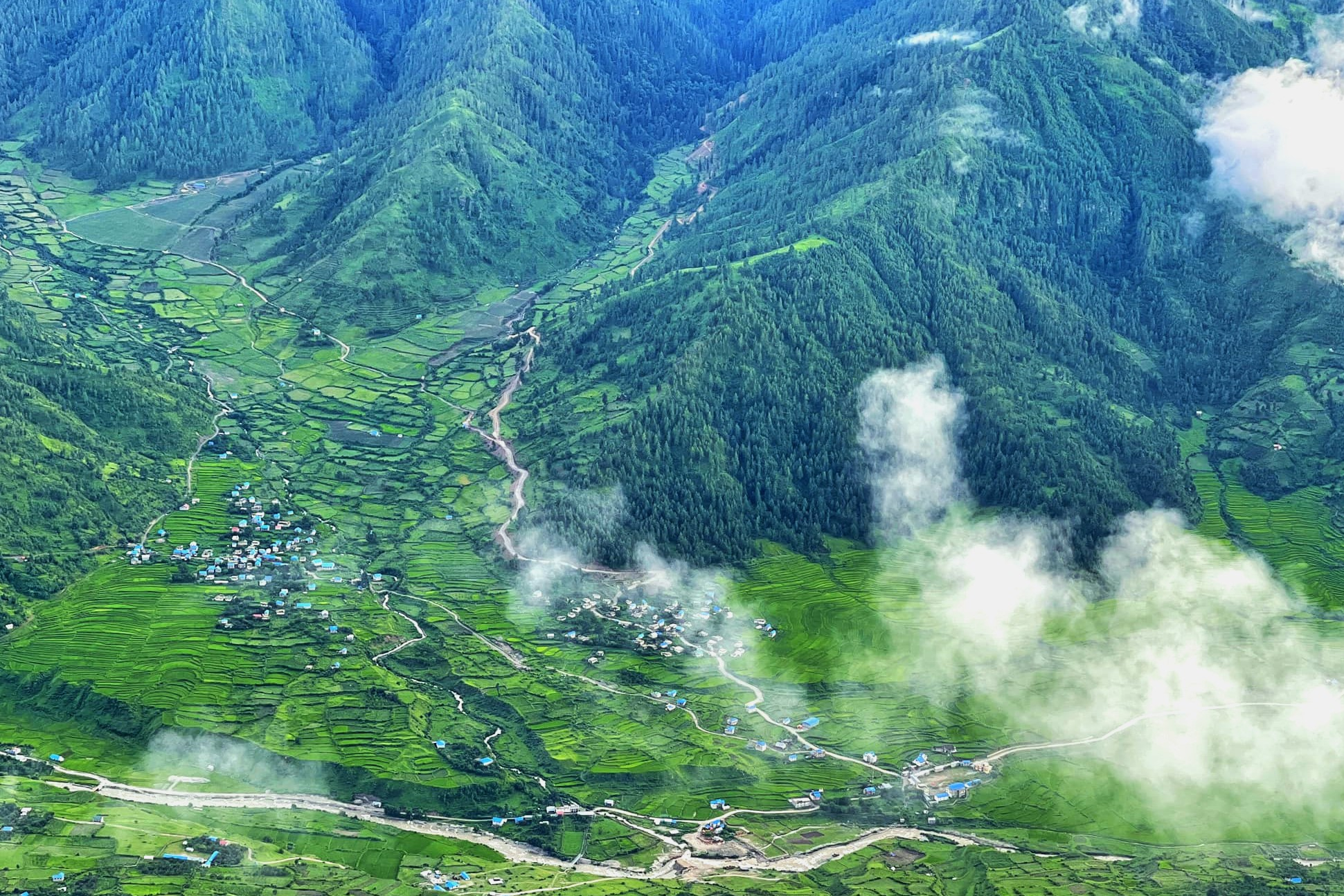
Today, you will cross over from Myagdi to Baglung and into the former Tibetan refugee camp. This trek offers an opportunity to discover areas, which is still virgin without being affected by western influences. This refugee camp was serviced by an airfield built by the Swiss in the 1950s. This is also the entrance to Dhorpatan, a Hunting Reserve, where you can spot mountain goats and blue sheep (Gharal). Dhorpatan is famous for its Moorland and plain land.  Dhorpatan hunting reserve is also an attractive destination, controlled hunting allowed with proper license and certain seasons in the year.   Dhorpatan reserve is the only one spot in Nepal where licensed hunting is permitted, it is characterizing by alpine, sub-alpine and high temperate vegetation. Common plant species include fir, pine, birch, rhododendron, hemlock, oak, juniper and spruce.  Dhorpatan is the prime habitats of blue sheep, other game species are Ghoral, Himalayan Tahr, Black Bear Pheasant and Partridge. Stay overnight at local lodge of Dhorpatan.

elevation

Max. altitude

2,860m / 9,383 ft.
accomodation

Accommodation

Hotel / Lodge

Early in the morning, you can stroll around the place for sometimes and enjoy the natural flora and fauna of this place. If you are lucky, you will be able to see the wild life of this place like: Ghoral, Himalayan Tahr, Black Bear Pheasant and Partridge. This place is also known as a paradise for birds. Watch Danphe (National bird of Nepal), pheasants, and other migratory species that you have seen only in bird guides. It is very hard to imagine that people have fought a war in such a peaceful place. There are cow sheds in the monsoon, but in the winter these high pastures are deserted. We will walk for about five hours to reach Nisi Dhor where we will stay for overnight.

elevation

Max. altitude

2,800m / 9,186 ft.
accomodation

Accommodation

Hotel / Lodge
meal

Meals

Lunch , Dinner , Breakfast

Trekking from Nisi Dhor, it takes about seven hours to reach Tallo Sera. Tallo Sera is rich in dense forest making it easy for the Maoist to hide during the insurgency. We have to cross over from Baglung and then to Rukum into Magar community and then enter the former Maoist base area. The village is very beautiful and one can have a wonderful sight form this place. Scenic beauty of this region is unmatched. One can have a breathtaking view of the Dhaulagiri range and wide meadows with pine trees.

elevation

Max. altitude

3,050m / 10,007 ft.
accomodation

Accommodation

Camping
meal

Meals

Lunch , Dinner , Breakfast

On the following day, we have to walk for about six hours to reach Rujhi Khola. Passing through Rukum, we walk through a pleasant trail today. Rukum is inhabited by Magars and Dalit (Low cast). This place is also not much explored by the tourist. Rukum has so many things to offer and will be fascinated by  traveling though several unspoiled villages, innocents people, their unique cultures, awesome Himalayan ranges of Sisne, Putha , Dhaulagiri, Chauri peaks. A great opportunity to learn Rich Kham Magar cultures, exceptional people’s lifestyles, seeing the war remnant, amazing view of Mt. Sisne (virgin), Putha, Chauri and beautiful landscapes are the main attraction in Rukum. Rukum, also known as the district of “52 lakes and 53 hills” could be a hit among tourists. There is plenty of sunshine for the remoteness of Rukum and Rolpa that was quelled into a seething pot of war once upon a time. We stay overnight at one of the lodges of Rujhi Khola.

elevation

Max. altitude

2,250m / 7,382 ft.
accomodation

Accommodation

Camping
meal

Meals

Lunch , Dinner , Breakfast

Leaving Rujhi Khola, we continue our trail further up to Thabang. Thabang is the cradle of the Maoist revolution. It was damaged in army attacks and parts of the town were flattened by ‘tora bora’ mortar shells dropped from helicopters. There has been some development of infrastructure after the war ended, and the people are eager to welcome the visitors and are very friendly and hospitable. The village is made up chiefly of Dalit and Magar and a giant, black and white mural greets you at the entrance with depictions of Marx, Engels, Lenin, Stalin and Mao. We stay overnight at one of the lodge of Thabang or Tented.


elevation

Max. altitude

2,350m / 7,710 ft.
accomodation

Accommodation

Camping
meal

Meals

Lunch , Dinner , Breakfast

Commencing our trek, we can see mixed forests of Rhododendron & Oaks. We can also view the scenery of beautiful forests, high mountains including Dhaulagiri Himal, Gurju Himal, Churen Himal, Putha Himal etc which can be observed on the way of Thabang to Jaljala where we will stay for our overnight. The highest point in Jaljala is Dharampani (3900m) and there is a great view from Api and Saipal in the west to Dhaulagiri in the east. Jaljala is open grassland, seasonally inhabited by herders. There are many shepherd huts and two small, rock built temples as well as a stone-walled, central pond. Ascend any of the smaller hills to improve views of the snowbound Himalayan peaks. The area and environment was a former highland training ground for guerrillas and now has a multi-storied temple, Bujuthan, with three water taps and nearby is Bhangma Pup (“Torch Cave”) a large cavern that also serves as a shrine. Dharampani, the name of a ridge top (11,572 ft, 3527 m) to the southwest, has a Maoist memorial.

elevation

Max. altitude

3,193m / 10,476 ft.
accomodation

Accommodation

Camping
meal

Meals

Lunch , Dinner , Breakfast

On this day, we will descend down from the high mountains on a flat trail. The group or people who are settled here are mixed of different tribes and they own have their own culture, customs and traditions. They live peacefully in harmony.  After a walk of about six hours from Jaljala, we reach Jelbang passing through, forests. Here we will spend overnight.

elevation

Max. altitude

3,100m / 10,171 ft.
accomodation

Accommodation

Camping
meal

Meals

Lunch , Dinner , Breakfast

This is the last day for trek as we will only be driving on the next day. At this point, we finally get to Rolpa and the road head. Rolpa was also a rebel base area and for many of the ten years of war under total Maoist control. We can eat at one of the many commune restaurants run by Maoist cooperative, where staffs are relatives of those who were killed in the fighting. After six hours of walk, we reach Sulichaur where we will stay overnight.

elevation

Max. altitude

1,860m / 6,102 ft.
accomodation

Accommodation

Camping
meal

Meals

Lunch , Dinner , Breakfast

On the last day of our journey, we take our breakfast in Sulichaur and then drive towards Kathmandu which will take about nine hours ride. With all the beautiful memories, we reach Kathmandu. Then you will be transferred to your respective hotel. Take some rest or take an evening walk. You will spend overnight at Kathmandu.


elevation

Max. altitude

1,380m / 4,528 ft.
accomodation

Accommodation

Hotel
meal

Meals

Lunch , Breakfast
Elevation Chart
Not satisfied with this itinerary? Make your own.
Plan My Trip

Includes

    • Domestic airports pick up and drop in Kathmandu as per program by private car
    • Accommodation during the trek with all meals (Lunch , Dinner and Breakfast) with Cup of Tea/Coffee and room sharing basis. 
    • Camping+lodge (whereas possible) trek with all meals (breakfast, lunch and dinner prepared by our cook) .
    • Services of an experienced English speaking trekking guide, cook, kitchen helpers and porters.
    • Food, salary (allowance), insurance, equipment and transportation for cook, assistance, porters etc. 
    • First aid kit bag
    • All equipment for camping (tent, mattress, kitchen tent, kitchen utensils, toilet tent etc)
    • Sleeping bag and down jacket if necessary.  
    • All applicable government taxes and service charges.

Doesn't Include

    • Any meals, accommodation and sightseeing in Kathmandu (if required please let us know and as per your budget requirement we would be very happy to arrange the same)
    • Bottled drinks (mineral water, any cold drinks, and alcoholic drinks).
    • Personal travel insurance against sickness, injury, accidents, damage or loss of goods.
    • Liability for extra expenses caused by illness, accidents or situation beyond our control. 
    • Expenses of personal nature such as laundry, telephone, bar bill, tips for driver, guide and porter, etc.
    • Medical and emergency evacuation charges.
    • Respective expenses if one returns earlier from the trip due to sickness or emergency purpose.
    • Personal equipment for Sunglasses, Sun hat, normal trekking booth, plastic trekking booth etc.
    • Tips for guide & porter and others staff.
    • Any other services or optional activities not mentioned above in the included list.
Why Book with Nature Trail
  • Earn US$ 25+ in travel credits.
  • Excellent customer service. Our travel experts are ready to help you 24/7.
  • Best price guaranteed.
  • No credit card or booking fees.
  • 100% financial protection. 
  • Carbon neutral tours.
  • 500+ trip reviews, with an average rating of 4.8 out of 5

Share this tour

Similar Tours

Royal Trek
Annapurna region
Trekking in Nepal
Best Selling
Beginner
(0 reviews)

Royal Trek

from US $ 1,040
US $ 760
6 days
Explore
Millennium Trek
Annapurna Region
Trekking in Nepal
Easy
(0 reviews)

Millennium Trek

from US $ 600
US $ 490
6 days
Explore
Rolwaling - Khumbu Trek
Gaurisankar & Everest Region
Trekking in Nepal
Offer Price
Difficult
(0 reviews)

Rolwaling - Khumbu Trek

from US $ 3,250
US $ 3,025
19 days
Explore
Upper Dolpo Trekking
Dolpa Region
Trekking in Nepal
Offer
Moderate
(0 reviews)

Upper Dolpo Trekking

from US $ 4,250
US $ 3,880
25 days
Explore
Jumla Simikot Area Trek
Rara National Park
Trekking in Nepal
Easy
(0 reviews)

Jumla Simikot Area Trek

from US $ 2,450
US $ 2,280
12 days
Explore
Lower Dolpo Trek
Dolpa Region
Trekking in Nepal
Special Offer
Moderate
(0 reviews)

Lower Dolpo Trek

from US $ 4,095
US $ 3,435
21 days
Explore
Book Now

Searching for exclusive travel deals?

Discover incredible offers for your upcoming adventure by subscribing to our newsletter with the latest travel tips and updates.

We are associated with