We first drive to Drukgyal Dzong (2580m) where the road ends. The next stop is the ancient ruins of Drukgyal Dzong (30 minutes). The Dzong is a monument to the Shabdrung’s victory against an invasion of allied Tibetan-Mongolian forces in 1649. The name “Drukgyal Dzong” thus translates to “Fortress of Victory”. The Dzong was destroyed in a fire in the 1950s. On clear days, Drukgyal is an excellent place to view the glorious mountain Jomolhari. The trek begins with a gradual climb and the trail follows the Paro Chhu passing beautiful meadows, paddy fields and impressive farm houses. After about four hours you will reach the army post at Gunitsawa village. At the army check post your trek permit will be checked and endorsed. The campsite is on the opposite side of the river, not far from Gunitsawa at an altitude of 2870 meter at Shana.


As your first day’s trek is the shortest trek, this day you will have to walk for about eight hours in order to reach Thangthangkha. You will hike through an undulating trail and then climb uphill till the valley narrows gradually to a path. You will then descend to a meadow where you will camp for the night. From your camp you can have the first view of the popular Mount Jomolhari on a clear day.
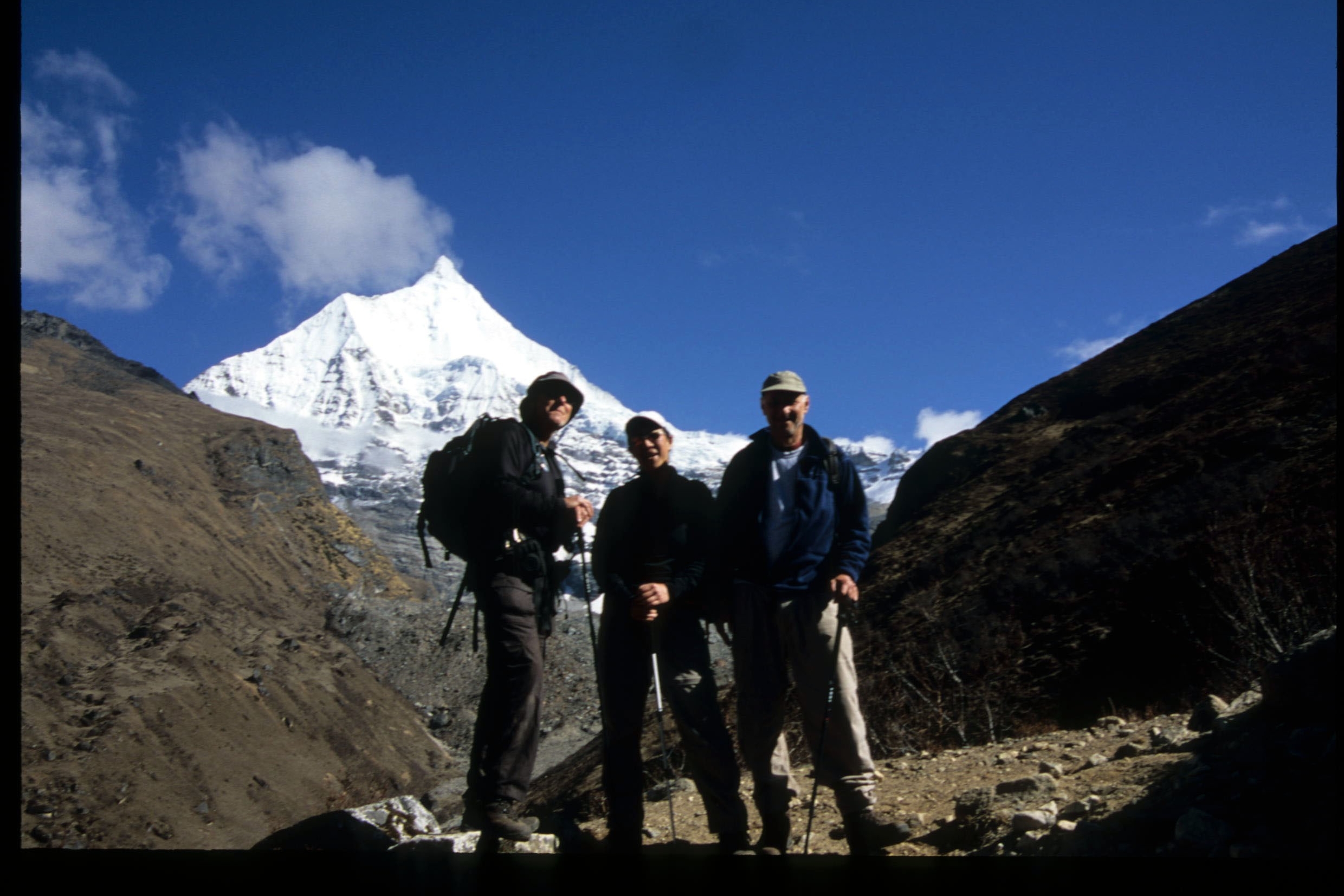
This morning the trek continues up the Paro Chhu valley which widens into patches of alpine meadow and scanty growths of forest. You will cross an army checkpoint along the way and enjoy a spectacular view of high mountain ridges and snow-capped peaks. In this area yaks and their herder’s homes become a regular feature of the landscape. You will continue to trek up the Paro Chhu valley. It widens into patches of alpine meadow and scanty forest growths. You will also cross an army checkpoint along the way. You will see local yak herders tending the yaks. You will pass the villages of Soe, Takethang and Dangochang. The view of Chomolhari (7,320 m) and Jichu Drake (6,900 m) is superb. Both the mountains are still virgin peaks.
This day is kept leisure at Jangothang. But you have the option to do day hikes, explore the surrounding areas like: Tshophu lake, Yak Herders and there are trails in three directions. If you love photography, you can engage yourself in lot of ways. Jomolhari and its subsidiary mountain chains lay directly west, Jitchu Drake to the north and there are a number of unclimbed peaks to the east. There are good chances to spot some blue sheep on the upper slopes of the valley. Jangothang is a perfect environment for your acclimatization.
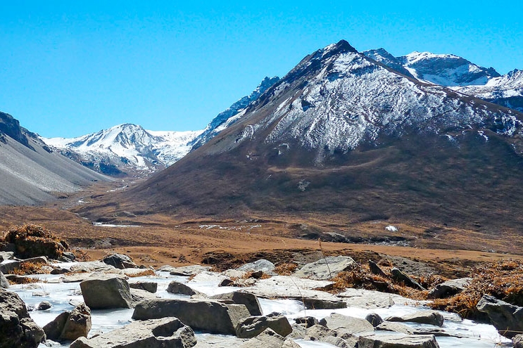
Today’s trail follows the stream for half an hour and crosses the bridge to the right side. Climb up the ridge and enjoy stunning views of Chomolhari, Jitchu Drake and Tsherim Khang mountains. Then walk through the wide open valley sometimes coming across herds of blue sheep. The climb up to the Nyele la pass (4,800 m) is not too difficult and the view is breathtaking. From the pass you will have spectacular views of Mt. Jomolhari, Jichu Drake and Tsherimgang, all of them rising above 7,000m. It’s a gradual descent to the camp where you will pass by some of the yak herder’s tents, made from yak wool. The herders use these tents while travelling to various pastures for their yaks. As you come down into the Lingshi basin, a beautiful U-shaped valley, you get a wonderful view of Lingshi Dzong on clear days. Tserimgang and its glaciers rise up at the north end of the valley. The campsite is next to a stone hut you reach just before Lingshi Dzong.
You will have an easier walk today. Shortly after starting you will reach a chorten below Lingshi Dzong. Here, you have the choice of staying on the main trail or taking a detour up to the Lingshi Dzong (4,220m), which sits right atop a high ridge. This Dzong is under reconstruction from a 2011 earthquake which damaged its central building. In addition to a very special atmosphere of mystic tranquility, Lingshi Dzong provides a great view over the valley. After Lingshi Dzong you will be passing the villages of Lingshi and Gangyul. In Gangyul, the stone houses are clustered together to form a small compact village that is unusual in Bhutan where settlements are usually scattered. On reaching the campsite at Chebisa you will have plenty of time to visit the village houses if you feel up to it. There is also a beautiful waterfall located behind the village that is worth visiting.
From your camp, you will ascent for about three hours through a pastureland toward Gobu La Pass (4,410m). The trail goes through wild pastures where yak grazes and you will see a few people herding yaks. There is also a great chance to spot large herds of blue sheep above the trail. After the pass descend to a lunch stop, through rhododendron bushes. Afternoon continue along the up and down path, after crossing the stream, through rhododendron forests and yak herders camp. We may see herds of Blue Sheep near the pass. The camp is near a tributary to the Mo Chhu which emerges below the Gasa Tsachu (Hot Spring). From here you can see the helipad which is sometimes used if the passes get snowed in.
The trek starts with a climb up the valley till you see Mount Kang Bum (6,526 m) and some edelweiss. You will climb again till you reach Jhari La (4,750m), from where you catch the first glimpse of Sinche La, the pass you will have to cross the day after. The big snow peak in the north is Gangchhenta (6,840 m), better known as the Great Tiger Mountain. If weather permits, Tserim Kang and the top of Jomolhari will be visible. Herds of takin, the Bhutanese National Animal, migrate to this valley in summer and remain for about four months. The valley has been declared a takin sanctuary. From here we may have to cross the stream as the foot bridge is often washed away. After crossing the stream towards the left, the trail climbs to reach Robluthang camp at an altitude of 4,400m. You will climb again till you reach your campsite at Robluthang.
You will begin the day with an ascent of about an hour after which the trail becomes more gradual for the next 90 minutes through a boulder field. You will climb uphill again for an hour to reach the Sinche La Pass (5,005m) – the final and highest pass on the trek if you don’t intend to continue the Snowman trek from Laya onwards. Then you descend and you can see an impressive terminal moraine and a glacial lake at the foot of the valley. You can see classic examples of lateral moraines where the glacier has pushed rocks up both sides of the valley. Below the moraine, you will cross the Kango Chhu and reach the Limithang campsite. Limithang is in the Laya district where the locals will be seen wearing unique regional dress. Our camp is at Kang Che Da beneath Gang Chen Ta, the Great Tiger Mountain, at an altitude of 4090 m. (19 km, 8 hours)
Walk downhill all the way along a narrow, winding river valley and enters the eastern end of Laya village (3820 m). The walk to Laya is very pleasant with incredible views. You will pass through dense forests, filled with moss and singing birds. From the west of the village you will have spectacular views of Mt. Gangchhenta and catch Mt. Masagang. Arrive at Laya village, the second highest settlement in the country, at an altitude of 3840 meter where you will camp overnight.
The trail winds up and down along the river valley of Mo Chhu avoiding natural obstacles and affording breath-taking views of the raging river, feeder streams and waterfalls. Lots of ups and downs will lead you to Kohi Lapcha at 3,300 m. The trek then drops down to the large stream of Koina Chhu, where you will find the campsite of Koina.
You will climb for the last time in the trek when you cross the Bale La Pass (3,740 m). You will then descend towards Gasa village (2,770 m) with a beautiful old Dzong. You can choose to camp near the Gasa Dzong or descend for another hour to the Gasa Tsachu (hot springs) and relax in the rejuvenating mineral waters. The Gasa Tsachu is one of the most popular hot springs in Bhutan.
Today’s trail winds through rolling hillsides with vistas of fields, villages, oak and Pine forests. Gasa Dzong will be visible behind you, glued to the valley wall. Today’s walk takes you through small settlements and finally at camp of Geon Damji village – a large village with rice terraces on the hillsides.
On the last day of trek, we leave Geon Damji and commence trek to Tashithang. After a walk for about 5 hours, you will reach the ending point of our trek where your vehicle will be waiting for your pickup. Drive to Punakha through the unpaved roads for about 5 to 6 kilometer. Overnight at Punakha.
On the last day of our tour, we drive to Paro after a short visit to Punakha Dzong. Punakha Dzong (fortress) was built between the confluences of two rivers the Pho (male) river and Mo (female) Chu. This Dzong is the winter home of the state monastic body and houses the District Administration office.

Discover incredible offers for your upcoming adventure by subscribing to our newsletter with the latest travel tips and updates.