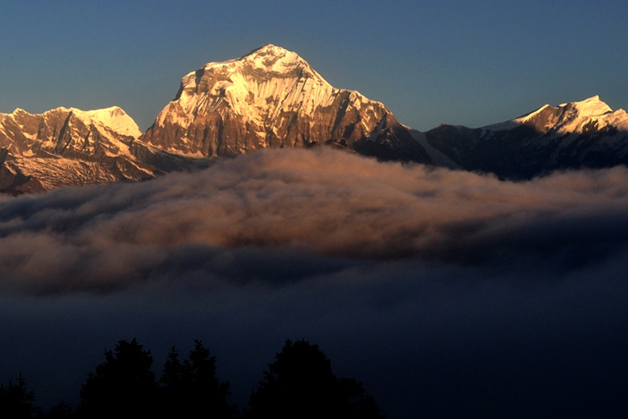
Mount Dhaulagiri (8137m), the seventh-highest peak in the world rises above the Kali Gandaki River, which flows between the Annapurna Massif and this awesome peak. The Dhaulagiri circuit trek is a strenuous trek that takes you through the high alpine pastures. Though it falls in the same region as Annapurna, one should not mistake to think this trekking trail is as easy as other trekking trails of Annapurna.
It is definitely not a standard trek, being tough and demanding, and has shocked many trekkers who expected something similar to the Annapurna Circuit or the Everest trek. The trail extends through one of Nepal’s wildest and most remote areas where the mountain scenery is simply breathtaking. If you are looking for an adventurous trek then this trek is definitely an ideal trek for you.
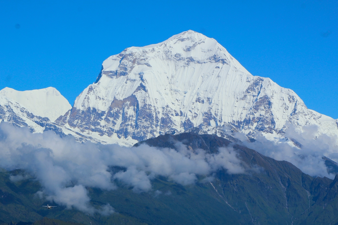
Dhaulagiri is derived from the Sanskrit word “Dhawala” which means “Dazzling white beautiful” and “Giri” which means Mountain. Thus giving its name a meaning Dhaulagiri provides you with its abundance of of beauty. This is without doubt the most astonishing one. Being the 7th Highest Mountain in the world, it lies 8167 meters above sea level.
It is located in the western part of Nepal and is probably the best spot for remote and adventurous trekking in Nepal. It consists of many peaks more than 7,000m of magnificent peaks with a land of dramatic contrast. Dhaulagiri was first discovered in 1808, and it was thought to be the highest mountain in the world by Westerners. It was assumed the highest peak for 30 years before its place was taken by Kanchenjunga. Today, it is popular among adventure seekers and mountaineers.
Dhaulagiri Circuit Trek is an arduous trek, through high alpine pastures, higher passes, and serene and uninhabited valleys. Recently reopened this thrilling region shows its long-kept secrets, like the Gandaki Gorge, the deepest Gorge in the world.
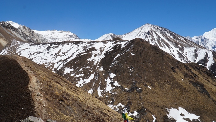
The trail passes through staggering alpine terrain. It is better labeled as an “extreme route”; extreme, because you need a rope and should also take ice axes and crampons. With its extended high-altitude nature it should only be attempted when snow-free, from late September to December or perhaps May and early June.
This means don’t go during March or April, these times can be particularly unpredictable and dangerous. There is a real rock fall danger in two places, and if it has rained recently it will rain rocks in a place that you have to trek under.
Dhaulagiri Circuit trekking follows glaciers and crosses high snowcapped passes, a challenge suited only to fit individuals wishing to go on remote demanding trekking in Nepal. Walk through the pristine valley of Myagdi, lush terraced hillsides, traditional villages, rugged terrain of massif Dhaulagiri, tough but technically straightforward French and Thapa passes are simply sensational for the everlasting memories of being in Nepal for strenuous trekking to Dhaulagiri.
From Dhampus Pass to near Yak Kharka, the trail is dangerous in snow. First, finding the trail is difficult and it traverses steep ground, second, there is real avalanche danger, and third, when the snow is melting, snow-water-ice streams flow and these are extremely dangerous.
That “extreme” word again. Getting trapped – if it snows during a trek, usually it is not a problem, and occasionally it may mean waiting a day or two for it to clear. Real snow (25cm+) in Hidden Valley will trap you and breaking trail on either trail out will be very dangerous. Ensure you make the right decisions. Ascending to Dhaulagiri Base Camps and through the Hidden Valley involves a dangerously sudden rise in altitude.
If you aren’t previously partially acclimatized you risk serious altitude sickness in an area that is tough to escape from. The trekking adventure, which encounters exceedingly beautiful Hidden Valley, allows the trekkers to literally touch the majestic mountain Dhaulagiri at Dhaulagiri Base Camp. Diverse culture, treading through different types of forests to treeless zones, and getting as close as possible to peaks like Dhaulagiri and Dhampus Peak are great highlights of Dhaulagiri Circuit Trek.
In comparison to the other treks of the Annapurna region, the Dhaulagiri circuit trek is a less crowded lodge and camping trek and offers a unique and incredible culture and mountain views. It is one of the most adventurous and challenging treks too. So, well-equipped and special physical fitness is required in order to trek around this area.
Starting our journey from Kathmandu, we drive towards Beni for about 8 to 9 hours. Throughout your drive, you will enjoy the beautiful scenario of mountains, forest and country side. Beni is a small town located at the confluence of the Kali Gandaki River and Myagdi River at an altitude of 899 meters. Two rivers meet at the junction so it is named as Beni. It is the district headquarters and has a police check post where your trekking permits will be examined. It is a bustling town lined with stores, restaurants, hotels and various government offices. Anyone can watch panoramic scene of Himalaya and landscape, can observe flora, fauna, and village life style also. Different kinds of tourism activities could occur in a place in a visit like recreational tourism, Eco-tourism, Village Tourism and Cultural Tourism etc. It is a significant pilgrimage itself along with several temples and monuments. It is the head quarter of Myagdi District. It is the main gateway to reach Mustang and Tibet. We stay overnight at this beautiful town.


Commencing trek from Beni, we walk west along the north bank of the Myagdi Khola through the village of BeniMangalghat to Singa and Tatopani. Today we’ll be trekking alongside the Kali Gandaki River before entering to the Myagdi Khola valley. After crossing the bridge beyond the village to the south bank of the river, the trail makes a little half loop before crossing another bridge near the village of Simalchour. After about 5 hours walk from Beni Bazaar, we reach to Babiachor where we will be spending our overnight.
Leaving Babiachor, we ascend uphill today passing through the terraced hills and village of Shahashradhaara. We then cross the Dudh Khola and walk through fields arriving at Ratorunga. From here the widened valley begins to narrow and terraces disappear on either side of the river. The trail is fairly moderate and winding path. We continue our walk up to the village of Dharapani for our overnight stay.
On the following day, we have a steep ascend up to Muri crossing the river and heading towards north of Phedi. Today’s trek will provide you the opportunity to have a clear magnificent view of Dhaulagiri along with other Mountains. In order to reach the west bank of Myagdi Khola, we have to cross the DharaKhola at first and there will be many switch-backs until you arrive at the ridge and the angle of ascent eases. Continuing our trek, we pass through Sibang and Mattim from where we incline up to the snout of the ridge and then descend to GattiKhola and reach PhalaiGaon (1810 m). Then climb a ridge to the large Magar village of Muri. You may have reached human habitation but the trail is still grotesque. It continues ascending and descending and crossing steep faces with gay abandon to the hamlet of Naura, half a day down. Slightly beyond is a choice between taking the shortcut across the MyagdiKhola to Malimpaa or Khibang or staying on the west bank for the longer but more scenic route via Muri and the delightfully situated village of Takum. Along this stretch are some shops and simple lodges.
Leaving behind Muri, we continue our trek to Boghara through Myagdi River via Naura Village. Today for few hours we’ll have an easy trek before making a steep climb to Boghara. We cross a stream and continue through terraced fields before climbing a ridge to reach the pass from where you can see Mt. Ghustung South (6465 m). Descend to the Myagdi Khola and trek along its West Bank to the village of Naura from where you will climb a little before traversing a grassy hill and climb a steep slope with switch-backs and then descend through a forest and terraced fields to Boghara. Although several grazing areas are named on maps the first village is Jeldung, 20 mins above Boghara (which is occasionally called ‘bugger-this!’). Overnight at Boghara.
Today the trail might be a bit tricky and might even require rope assistance on the way. Here we need to be careful and watch our steps. The trail continues through a forest to LapcheKharka via Jyardan which is the most remote permanent settlement in this part. Pick up the delightfully small trail that wind through pleasant forest. After the settlement a high winding path crosses a rocky area and then descends before climbing again to Lipshe where there is a single hut. After crossing several streams there is a particularly beautiful forest camp among huge cedar trees. Further down are several bridges to the west bank, one of which you should cross. The roller-coaster trail stays on the west side and crosses several streams on flimsy bridges. The trail continues through a forest to LapcheKharka and then climbs to the level area at Doban. Doban is a small clearing amid the forest, and has two simple teahouses that are often open during the trekking seasons.
After breakfast, we commence our trek by crossing a wooden bridge out of Doban. The trail ascends through a forested area and from the breaks of trees; you will get the opportunity to face west part of Dhaulagiri I (8,167m). After a short descend to the Myagdi Khola crossing via wooden bridge to the east bank, you will reach to Chartare. Then you cross the rocky area and a stream via forested trail you reach to ChoribanKhola. You will spend overnight in ChoribanKhola.
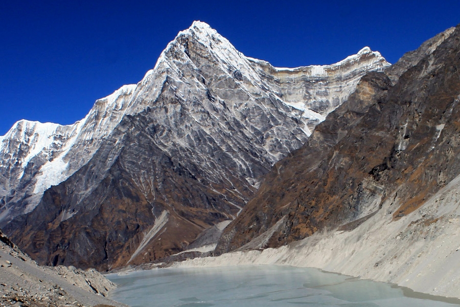
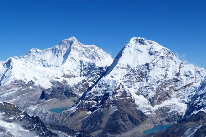
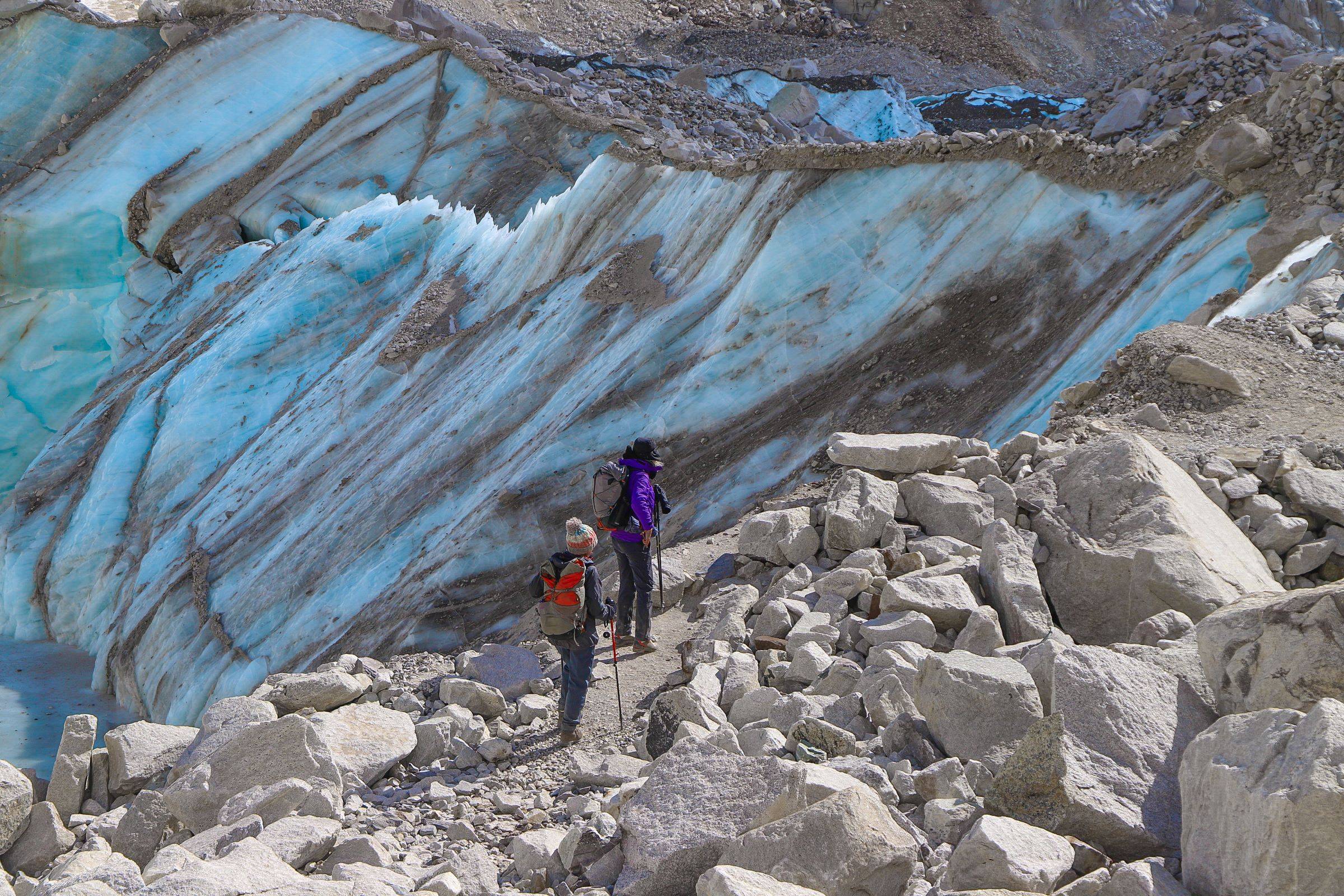
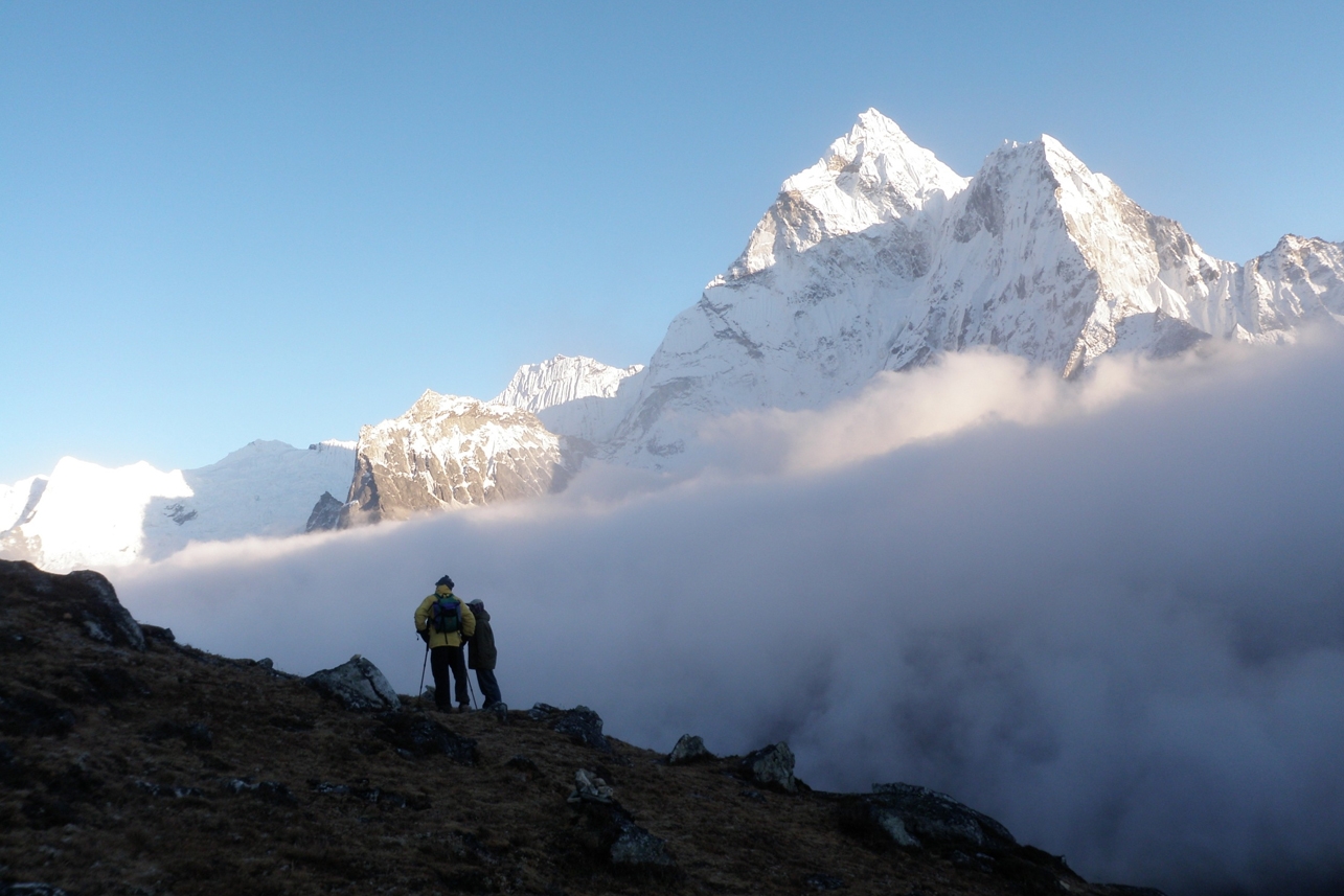
Today we’ll walk across some beautiful forests and alongside the spectacular mountain views before reaching to Italian base camp. Passing through beautiful forest we rapidly gain altitude and mountains burst out all around. After a steep descent the trail abruptly falls down dangerous moraine to cross the incoming glacier. Groups have often had to make their own trail down using shovels and setting up a hand line. The trail leads to Chhonbarban Glacier and from the right side of the glacier we will be able to see the view of Dhaulagiri. Tukuche Peak (6837 m) becomes visible straight on; at the far end while the impressive north flank of Dhaulagiri I (8167 m) dominates the skyline to your right. Ascending the moraine on the other side is steep and definitely requires a rope and somebody game enough to climb it first without a rope. The grassy area is called Italy Base Camp. There are simple shelters here open during the season. Here we’ll set our camp just opposite the west wall of Dhaulagiri. To the west are the peaks of Dhaulagiri II (7751m), Dhaulagiri III (7715 m) and Dhaulagiri V (7618 m).
Today will be the first day for acclimatization during the trek. It is recommended that your body acclimatizes to the high altitude and be adjusted for higher altitudes in the days to follow. Thus, we will spend a day acclimatizing to the thinning of the air. Taking rest in this day will also help you to prepare for the upcoming trails.
As your trail passes through a narrow gorge, you likely have to experience a stone fall today so we recommend you to set up early in the morning when the weather is expected to be clear. After crossing the first glacier, probably using a rope in a couple of tricky spots, we climb onto the main glacier. The surroundings are spectacular, which makes up for the rough and dangerous trail. After an adventurous walk for about 6 hours, we reach to the main Glacier camp where we will tent for our overnight.
Today you will be reaching the main destination of the trek “Dhaulagiri Base Camp”. Today’s walk will be very exciting as well as very difficult for us. You will have an adventurous walk over the smooth white part of the glacier. Steady climb through the rough and chilling part will give you a spectacular view of Dhaulagiri Base Camp. Tukuche Peak (6837 m) becomes visible straight on at the far end while the impressive north flank of Dhaulagiri I (8167 m.) dominates the skyline to your right. To the west are peaks of Dhaulagiri II (7,751m), Dhaulagiri III (7,715m) and Dhaulagiri V (7,618m). In front of you is the impressive icefall that descends from the north-east col.
We will be spending our second rest day at the Dhaulagiri Base Camp. This day is kept leisure in order to acclimatize to the lower air pressure rather than taking a rest. You days will be spent in an instant as you can get an opportunity to have superb views of Tukuche Peak (6837 m), Dhaulagiri I (8167 m), Dhaulagiri II (7751 m), Dhaulagiri III (7715 m) and Dhaulagiri V (7618 m). Today’s acclimatization is a must in a sense that the day after will be a tough day since you have to walk on the altitude of 5000 to 6000 meters.
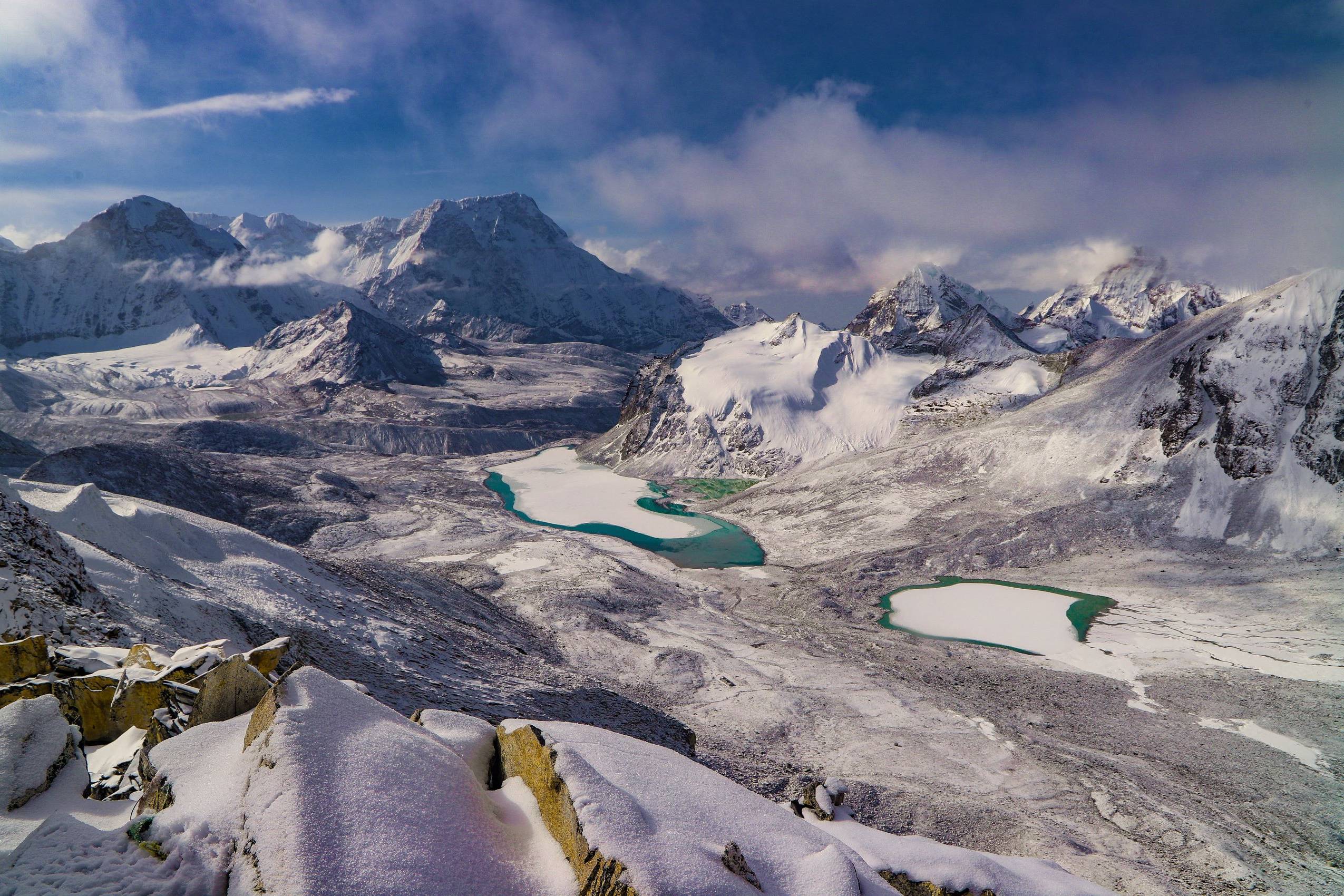
Today also we’ll be requiring the rope assistance and after a few more ups and downs and getting over the steep moraine walls, we descent from the French pass to the safer and smooth part of the country after a breathless climb to the top of French pass. After the glacier you climb two terraced hills, the first of which runs along the glacier, then cuts across the mountain flank and the moraine you enter a gentle incline on the left from an ablation valley. Climb this gentle slope to the French Pass (5,360m). A great vista opens up from the French Pass and you will be able to see Mukut Himal (6,328m), Tashi Kang (6,386m) and SitaChuchura (6,611m), all of which surround the Hidden Valley. To the south is Tukuche Peak (6,920m) and beyond is the massive peak of Dhaulagiri I. From the French Pass you continue along the right edge of the Hidden valley losing a little altitude to the Thapa Pass (5,250m) between Tukuche Peak and Thapa Peak (6,012m). Descending from the Thapa Pass you will make it to the camp in Hidden valley at 5200 meters.
Today, we descend from the hidden valley located at an altitude of 5200 meters to Dhampus and then to Yak Kharka. Admiring the surrounding peaks, we walk downwards the hill. We traverse avalanche prone slopes and then descend steeply to Yak Kharka. There is a perfect camp site to enjoy the surrounding and many roofless shelters, only a couple of which are near the small year-round water supply. These are several hours from the roofed summer houses, and roughly in the middle of the vast hillside.
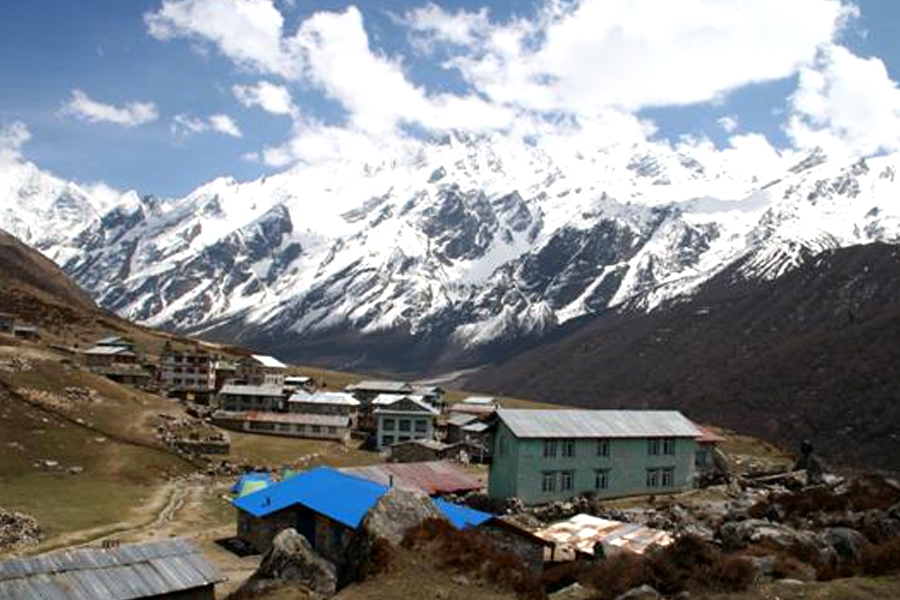
After breakfast, we descend down the hill to the village of Marpha which is located on the west bank of the Kali Gandaki River. Marpha is home to many apple orchards as well as all various food products made from the fruit. Don’t forget to taste the local Apple Brandy a specialty from the region that you may be lucky enough to taste en route. Overnight stay in Marpha village.
Our trek has ended and we drive back to Pokhara today to enjoy the lakeside restaurants and bars and perhaps be overwhelmed by the sights and sounds of a busy town after the wilds of the mountains.
Today we say goodbye to the Fishtail Mountain which towers over Pokhara and to the wonderful Himalayas mountains that have been our home for the past 2 weeks or so. Then it’s time to say goodbye to your wonderful staff as the comfortable tourist bus gets you back to Kathmandu in time to head off to a lively restaurant for dinner and perhaps some music.


Discover incredible offers for your upcoming adventure by subscribing to our newsletter with the latest travel tips and updates.