
After breakfast, we will take an hour long flight from Kathmandu to Nepalgunj, which lies close to the Indian border in the western Terai. Nepalgunj, a town near the Nepal-India border, is also the gateway to Simikot, Humla. The town itself is an interesting Terai town that showcases the diverse culture of Nepal. We will stay there for overnight and make the necessary preparation for the trek ahead. We can also visit local market of Nepalgunj, mini – zoo and nearby villages. Overnight accommodation will be in a lodge.


Early in the morning, we take a flight from Nepalgunj to Jumla. After arriving at Jumla airport, we will cross the Tila Khola and the Chaudabise Khola, near their confluence and climb gradually to a fertile valley of rice terraces. The trail passes through several villages. We continue our walk through a forest of maple and walnut and onto a meadow which, in season, is covered with wild flowers. Beyond the meadow, the trail climbs to a small pass before descending again to Gothi Chaur where we will be staying for the night.
Today, the trail follows the Tila Khola through fields of corn, potato, buckwheat and barley until the valley narrows and then we will be entering a forest of oaks, spruce and maples. We will be passing through the village of Chotra which is dotted with typical Tibetan mani walls. After a short distance, we will come to another Tibetan-looking village, Naphukana where we will be staying for the night. There is a large Gompa above this village.
The trail today becomes gradually steeper and climbs through a forest to a pass named Mauri Lagna (3820m). From the pass, one can get views of snowy peaks to the north and east. Descending from the pass, the trail traverses a steep slope before dropping into a forest of pine and oaks. We then enter the Bheri Valley and after following the trail in and out of side valleys, we will come to the village of Chaurikot where we will be staying for the night.
The trail proceeds on to the village of Balasa from where we will be able to see Kagmara peak on the horizon. The trail descends to a stream before climbing through a forest of walnut trees and onto a ridge. Passing through the apple orchards of Jyakot, we will then descend to the village of Rimi before following a rocky trail down to the Bheri Riverside where we will be staying for the overnight.
We will continue our trek along the west bank of the Bheri River, passing Hurikot. After arriving at the entrance of the Shey Phoksundo National Park, we will then come to the confluence of the Garpung and Jagdula Khola, which joins the Bheri River. We then move forward towards Garpung khola where we will be staying overnight.
Today will be a short trek. We will continue to follow alongside the Garpung Khola, ascending gradually towards the Kagmara La. Today’s trek is mainly done for acclimatization. It is important to note that ascending to great latitude too quickly is risky so we need to take enough rest before heading forward. Overnight at Kagmara.
We will be crossing across to the eastern side of the river, where the valley narrows and the river becomes a series of waterfalls. The trail climbs to a moraine below the Kagmara La and we will make our camp amidst the boulders. Magnificent views of the surrounding peaks will be at our door step.
Today, we will start early in the morning and ascend alongside the Kagmara Glacier to the Kagmara La. This is a good place to spot the rare blue sheep. After a 900m descent, we will reach the pastures of the Pungmo Khola Valley where we will be spending the night.
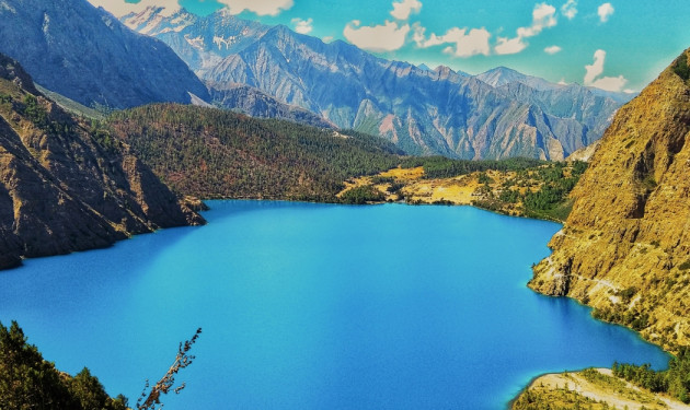
On the following day, we will be continuing downstream to the national park headquarters at Sumduwa before joining the trail up the Phoksundo Khola to Phoksundo Lake. We will climb through a forest of large cedars to the winter settlement of Palam and continue ascending through the open country to a ridge from which there are good views of the lake in the horizon. There is a spectacular waterfall- the highest waterfall in Nepal close by. The trail then makes an initial descent before climbing gently to Ringmo village. After crossing a bridge below Ringmo, the trail continues northward to the shores of Phoksundo Lake where we will be staying overnight.
Today will be a rest day at the lake which is known for its unusual greenish-blue water. In the backdrop of the lake on the western side, there is large snowy peak known as Kanjirolba or Kanchen Ruwa which seems like it is piercing the sky. A trail leads through a stand of juniper trees to an old dilapidated gompa which overlooks the lake. As well as Buddhist paintings and statues, there is also evidence of the ancient Bon-po religion within the temple and chapels.
Retrace our foot prints back to Ringmo and we follow a trail eastwards, through forest of juniper and blue pine. The trail follows alongside the river up the valley to a waterfall and eventually to the base of the Baga La where we will be staying for the night.
Today, our trek is a bit challenging as we have to begin our steep climb for 3 hours to the top of the Baga La Pass, the second of such high passes. From here, we get fantastic views of the dry landscape and the distant snow-capped mountains including Mt. Kanjirowa. We spend some time at the top of the pass taking pictures and generally enjoying the mesmerizing views. Then we descend gradual at first to Dajok Tang but it soon drops steeply to a stream before ascending again to the foot of the Numa La where we will be staying for the night.
On the following day, we continue to trek gradually ascending through arid country to the last of the high passes, the Numa La. We walk alongside Tarap Chu river and take pleasure in the amazing views of the vast Tarap valley with its wide plains and high mountains. It is marked by mani stones and the flutter of the prayer flags. If it is clear, we will be able to see as far as Dhaulagiri from the top. We cross a narrow gorge and leave the tree line behind us and welcome wild rose and juniper bushes, typical of the dry inner Himalayan valleys. The trail now descends past a huge mani wall to the Tarap region and the trail cuts through the barley fields of the Tarap Valley and onto the settlement of Do. After walking for several more hours, we reach the village of Dho Tarap which is surrounded by an irregular stone wall. In this Valley both Bon Po and Chaiba religious sects reside together. Tarap is also inhabited by a few Tibetans and mostly Magars who have lived here for many generations.
The day off will assist with acclimatization and allow some bodily rest. We can spend the day visiting nearby monasteries. It is the largest settlement in Tarap and has several Gompa. On the ridge above the village is the Ri Bhunpa Gompa and, just to the east lays the village of Shipchhok which has a Bon-po gompa which is certainly worth exploring. During today’s short walks, we also get a chance to get acquainted with the local culture. The Dolpo people wear homespun clothing that is sometimes dyed a maroon color and they favor Tibetan style somba or dhocha (boots with upturned toes) for foot wear. Both men and women often wear religious amulets and strings of coral, amber and turquoise. The people of the region are both Bon Po and Nyingmapa (Buddhist sects). Overnight at Dho.
On the ridge above the village is the Ri Bhunpa Gompa and, just to the east lays the village of Shipchhok which has a Bon-po gompa which is certainly worth exploring. We will be starting off early in the morning. We walk alongside Tarap Chu river and cross it twice before reaching Sandul Gompa. The gompa lies at a juncture between Barbung Khola and Tarap Chu river. We continue walking on a trail that takes us through farm terraces and rural villages. The trail is almost flat and follows the river until we come across a gorge. We will enter the gorge which has large rose shrubs and other wildflowers, and after crossing and re-crossing the river numerous times, the trail opens up to a flat expanse and onto Lahini where we will be staying for the night.
After breakfast our trek continues along the southern bank of the Bheri River heading upstream on an easy trail. Eventually, the valley widens and the route becomes easier as we approach the village of Khanigaon. Along the way, we pass through several deep gorges, hanging bridges and isolated villages. Our trail also includes a tremendous gorge with pine trees and a path built about seven meters above the river. After walking for a while, we will be greeted by the colorful, terraced field of Tarakot, a small village that stands on a hillock to the south of the Bheri River.
Commencing trek to Dunai, we will follow alongside the Barbung Khola downstream along the south bank to the village of Lawan, before crossing to the north bank and walking for several more hours to Dunai where we will be staying for the night.
Our trail today follows the river trail downstream to Juphal. The route along the Sulighat is surrounded by birch trees. From a top a ridge, we get the most spectacular views of the mountain above us and Jhupal Village below. We will also be walking uphill through meadows and past a few houses to the small hotels at Kala Gaura (2090m) where we can rest. After several more hours of walking, we will finally reach Juphal, which is the end point of our trek. Exploring busy market town of Juphal we will be stay overnight there.
In the last day of our journey, we will take an early morning flight from Juphal to Nepalgunj and connect flight from Nepalgunj to Kathmandu. Upon our arrival in Kathmandu, we will be transferred to our hotel. Overnight in Kathmandu.

Discover incredible offers for your upcoming adventure by subscribing to our newsletter with the latest travel tips and updates.